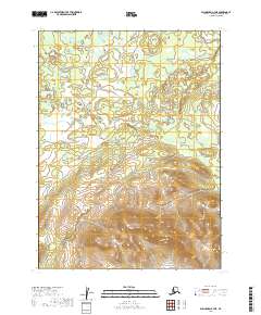
2019 Map of Dillingham B-7 NE
USGS Topo · Published 2019About this map
Nameless Cr flows through this remote section of the Alaskan landscape, situated within the Dillingham Census Area. The terrain transition is marked by a dramatic shift from the low-lying wetlands and scattered ponds in the north to the high-elevation ridges of the southern portion of the quadrangle. These steep slopes, reaching several hundred feet in height, are defined by the t9s r54w and t9s r53w township boundaries. The lack of named settlements or infrastructure reflects the undeveloped nature of this region during the 2010s, where the natural hydrography and topography are the primary features of interest for those studying the Dillingham interior.
Find a feature on this map
5 named features on this map. Tap any name to fly to it.
Don’t see what you’re looking for? This feature index may not catch every label — zoom into the map to look around manually.
Map Details
Editions of this 2019 Dillingham B-7 NE Map
This is the sole edition of this map. No revisions or reprints were ever made.
Other maps of this area

1951 · Dillingham
USGS Topo · 1:250,000

1954 · Dillingham
USGS Topo · 1:250,000

1954 · Dillingham C-6
USGS Topo · 1:63,360

1954 · Dillingham B-7
USGS Topo · 1:63,360

1954 · Dillingham B-6
USGS Topo · 1:63,360

1954 · Dillingham C-7
USGS Topo · 1:63,360
2019 · Dillingham B-6 SW
USGS Topo · 1:25,000

2019 · Dillingham C-6 SW
USGS Topo · 1:25,000
2019 · Dillingham B-6 NW
USGS Topo · 1:25,000
2019 · Dillingham C-7 SE
USGS Topo · 1:25,000