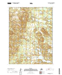
2019 Map of Dillingham C-7 SE
USGS Topo · Published 2019About this map
Okstukuk Lake and Oksuguokok Lake dominate this sub-arctic wetland landscape, located within the Dillingham Census Area. The terrain is characterized by a dense network of glacial lakes and slow-moving waterways, including the Kokwok River which meanders through the northeastern corner and Akulthierak Cr draining toward the southern basins. A notable topographic high point, Ka-ki-ak-tu-dli-ok, rises above the surrounding flats in the eastern section of the quadrangle.
Find a feature on this map
12 named features on this map. Tap any name to fly to it.
Don’t see what you’re looking for? This feature index may not catch every label — zoom into the map to look around manually.
Map Details
Editions of this 2019 Dillingham C-7 SE Map
This is the sole edition of this map. No revisions or reprints were ever made.
Other maps of this area

1951 · Dillingham
USGS Topo · 1:250,000

1954 · Dillingham
USGS Topo · 1:250,000

1954 · Dillingham C-6
USGS Topo · 1:63,360

1954 · Dillingham B-7
USGS Topo · 1:63,360

1954 · Dillingham B-6
USGS Topo · 1:63,360

1954 · Dillingham C-7
USGS Topo · 1:63,360

2019 · Dillingham C-6 SW
USGS Topo · 1:25,000
2019 · Dillingham B-6 NW
USGS Topo · 1:25,000
2019 · Dillingham B-7 NE
USGS Topo · 1:25,000
2019 · Dillingham B-7 NW
USGS Topo · 1:25,000