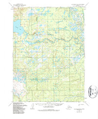
1954 Map of Dillingham D-6
USGS Topo · Published 1987About this map
The Nuyakuk River meanders through a landscape defined by water and glacial influence in the mid-1950s. This survey, based on aerial photographs from 1953 and 1955, shows the vast expanse of the Wood River Tikchik State Park. The terrain is marked by the presence of a Park Boundary and the expansive Tikchik Lake in the northwest corner. Human activity is sparse, indicated primarily by isolated infrastructure and remnants of earlier habitation.
Find a feature on this map
8 named features on this map. Tap any name to fly to it.
Don’t see what you’re looking for? This feature index may not catch every label — zoom into the map to look around manually.
Map Details
Editions of this 1954 Dillingham D-6 Map
2 editions found
Other maps of this area

1950 · Taylor Mountains
USGS Topo · 1:250,000

1951 · Taylor Mountains
USGS Topo · 1:250,000

1951 · Dillingham
USGS Topo · 1:250,000

1954 · Taylor Mountains
USGS Topo · 1:250,000

1954 · Dillingham
USGS Topo · 1:250,000

1954 · Dillingham C-6
USGS Topo · 1:63,360

1954 · Dillingham D-6
USGS Topo · 1:63,360

1954 · Dillingham D-7
USGS Topo · 1:63,360
1954 · Dillingham D-5
USGS Topo · 1:63,360

1954 · Taylor Mountains A-5
USGS Topo · 1:63,360