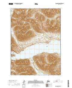
2019 Map of Dillingham D-8 SW
USGS Topo · Published 2019About this map
The Wood River Mountains dominate the northern landscape of this region, where the terrain drops sharply toward a massive freshwater system. Lake Kulik spans the center of the sheet, acting as a terminal point for local drainage before water moves south. At the southern edge, the Wind River flows through a narrow corridor between high ridges to reach the shores of Mikchalk Lake. This 2019 survey documents a wilderness area defined by significant elevation changes, ranging from the summit of Eagle Mtn in the northwest down to the glacial lake basins. The alignment of these water bodies suggests a landscape shaped by ice and flow, with the lakes serving as the primary geographic anchors for the Dillingham Census Area.
Find a feature on this map
13 named features on this map. Tap any name to fly to it.
Don’t see what you’re looking for? This feature index may not catch every label — zoom into the map to look around manually.
Map Details
Editions of this 2019 Dillingham D-8 SW Map
This is the sole edition of this map. No revisions or reprints were ever made.
Other maps of this area

1951 · Dillingham
USGS Topo · 1:250,000

1951 · Goodnews
USGS Topo · 1:250,000

1954 · Dillingham
USGS Topo · 1:250,000

1954 · Dillingham D-8
USGS Topo · 1:63,360

1954 · Dillingham C-8
USGS Topo · 1:63,360

1979 · Goodnews Bay D-1
USGS Topo · 1:63,360

1979 · Goodnews Bay
USGS Topo · 1:250,000

1979 · Goodnews Bay C-1
USGS Topo · 1:63,360
2019 · Dillingham C-8 NW
USGS Topo · 1:25,000
2019 · Goodnews Bay D-1 NE
USGS Topo · 1:25,000