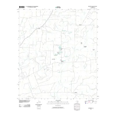
2010 Map of Dilworth
USGS Topo · Published 2010About this map
Little New York and the surrounding Gonzales County countryside are defined by a network of small creeks and managed water resources. This landscape, as it appeared in 2010, shows a pattern of rural settlement anchored by historic locations like Dilworth, Saturn, and Hickston. A notable concentration of dammed water bodies, including Kelley Lake Number 1 and Mercer Lake Number 1, highlights the importance of water management in this agricultural region. Local genealogy and history are preserved at sites like the Saint James Cemetery and through distinct terrain markers such as Pettit Prairie Flats and the Comanche Crossing over Peach Creek. The terrain is characterized by the confluence of numerous watercourses, with Sandy Fork and Denton Creek carving through the prairie to join larger systems, while named landmarks like Pin Oak Mound provide localized relief in the topography.
Find a feature on this map
65 named features on this map. Tap any name to fly to it.
Don’t see what you’re looking for? This feature index may not catch every label — zoom into the map to look around manually.
Map Details
Editions of this 2010 Dilworth Map
This is the sole edition of this map. No revisions or reprints were ever made.
Other maps of this area

1901 · Flatonia
USGS Topo · 1:125,000

1953 · Seguin
USGS Topo · 1:250,000

1958 · Seguin
USGS Topo · 1:250,000

1959 · Gonzales South
USGS Topo · 1:24,000

1959 · Hamon
USGS Topo · 1:24,000

1962 · Dilworth
USGS Topo · 1:24,000
1962 · Gonzales North
USGS Topo · 1:24,000
1964 · Sandy Fork
USGS Topo · 1:24,000

1964 · Waelder
USGS Topo · 1:24,000
1965 · Flatonia NW
USGS Topo · 1:24,000