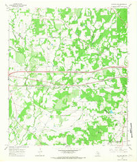
1965 Map of Flatonia NW
USGS Topo · Published 1967About this map
The Southern Pacific railroad and a developing highway network define this mid-1960s portrait of the Texas blackland prairies along the borders of Fayette and Gonzales counties. Near the small settlement of Armstrong, the landscape is a mix of agricultural pasture and scattered industrial activity, evidenced by numerous Oil Wells, Drill Holes, and a Claypit. This era of transition is visible in the placement of a modern Rest Area along the corridor, even as older rural landmarks like Mt Olive Cem and Cochran Cem anchor the surrounding family holdings. The geography is deeply carved by drainage systems like Peach Creek and Big Fivemile Creek, which flow toward the southern edge of the quadrangle near Russell Hill. For genealogists, the map is particularly valuable for its documentation of several family and community burial grounds, including the Andrews Chapel Cem and Castleman Cem.
Find a feature on this map
34 named features on this map. Tap any name to fly to it.
Don’t see what you’re looking for? This feature index may not catch every label — zoom into the map to look around manually.
Map Details
Editions of this 1965 Flatonia NW Map
2 editions found
Other maps of this area

1901 · Flatonia
USGS Topo · 1:125,000

1953 · Seguin
USGS Topo · 1:250,000

1958 · Seguin
USGS Topo · 1:250,000

1962 · Dilworth
USGS Topo · 1:24,000

1964 · Waelder
USGS Topo · 1:24,000

1964 · Jeddo
USGS Topo · 1:24,000

1965 · Muldoon
USGS Topo · 1:24,000

1965 · Cistern
USGS Topo · 1:24,000

1965 · Komensky
USGS Topo · 1:24,000

1965 · Flatonia
USGS Topo · 1:24,000