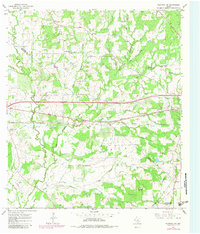
1965 Map of Flatonia NW
USGS Topo · Published 1982About this map
The rolling prairies and wooded creek bottoms of Fayette and Gonzales counties are captured here in a period of agricultural and industrial stability. Small rural hubs like Armstrong and Newtonville anchor the landscape, while the Southern Pacific railroad and U.S. Route 90 provide the primary east-west corridors for commerce and transit. The map reveals a dense network of family and community burial grounds, including Cochran Cem, Andrews Chapel Cem, and Mt Olive Cem, which serve as vital markers for local genealogical research.
Find a feature on this map
41 named features on this map. Tap any name to fly to it.
Don’t see what you’re looking for? This feature index may not catch every label — zoom into the map to look around manually.
Map Details
Editions of this 1965 Flatonia NW Map
2 editions found
Other maps of this area

1901 · Flatonia
USGS Topo · 1:125,000

1953 · Seguin
USGS Topo · 1:250,000

1958 · Seguin
USGS Topo · 1:250,000

1962 · Dilworth
USGS Topo · 1:24,000

1964 · Waelder
USGS Topo · 1:24,000

1964 · Jeddo
USGS Topo · 1:24,000

1965 · Muldoon
USGS Topo · 1:24,000

1965 · Cistern
USGS Topo · 1:24,000

1965 · Komensky
USGS Topo · 1:24,000

1965 · Flatonia
USGS Topo · 1:24,000