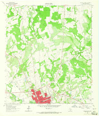
1962 Map of Gonzales North
USGS Topo · Published 1965About this map
The Guadalupe River and San Marcos River converge just south of the historic city center of Gonzales, establishing a landscape defined by meandering watercourses and fertile bottomlands. This 1962 survey illustrates the town's expansion northward, where the Southern Pacific line and an Old Railroad Grade track through the terrain alongside Tinsley Creek. The map provides significant detail for genealogists, documenting the Masonic Cem, Odd Fellows Cem, and the more distant Denton Creek Cem.
Find a feature on this map
36 named features on this map. Tap any name to fly to it.
Don’t see what you’re looking for? This feature index may not catch every label — zoom into the map to look around manually.
Map Details
Editions of this 1962 Gonzales North Map
Other maps of this area

1901 · Flatonia
USGS Topo · 1:125,000

1911 · San Marcos
USGS Topo · 1:125,000

1919 · San Marcos
USGS Topo · 1:125,000

1920 · Smiley
USGS Topo · 1:125,000

1925 · San Marcos 4-a
USGS Topo · 1:48,000

1929 · Luling
USGS Topo · 1:62,500

1953 · Seguin
USGS Topo · 1:250,000

1958 · Seguin
USGS Topo · 1:250,000

1959 · Ottine
USGS Topo · 1:24,000

1959 · Cost
USGS Topo · 1:24,000