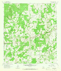
1964 Map of Sandy Fork
USGS Topo · Published 1966About this map
The Southern Pacific railroad corridor serves as the primary industrial axis for this section of South Texas, connecting the settlements of Harwood and Thompsonville across a landscape of cattle country and creek drainages. Field checked in the mid-1960s, the map reveals a rural community structure centered on localized gathering points such as Mt Zion Ch and St Union Ch. The topography is defined by the winding course of the Sandy Fork and its tributaries, including Scull Creek and Reed Creek, which flow through a mix of wooded creek bottoms and open pastureland.
Find a feature on this map
25 named features on this map. Tap any name to fly to it.
Don’t see what you’re looking for? This feature index may not catch every label — zoom into the map to look around manually.
Map Details
Editions of this 1964 Sandy Fork Map
2 editions found
Other maps of this area

1901 · Flatonia
USGS Topo · 1:125,000

1911 · San Marcos
USGS Topo · 1:125,000

1919 · San Marcos
USGS Topo · 1:125,000

1925 · San Marcos 1-d
USGS Topo · 1:48,000

1925 · San Marcos 4-a
USGS Topo · 1:48,000

1929 · Luling
USGS Topo · 1:62,500

1930 · Lockhart
USGS Topo · 1:62,500

1953 · Seguin
USGS Topo · 1:250,000

1958 · Seguin
USGS Topo · 1:250,000

1959 · Ottine
USGS Topo · 1:24,000