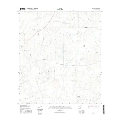
2016 Map of Dilworth
USGS Topo · Published 2016About this map
Saint James Cem and the settlement of Dilworth anchor the southeastern portion of this Gonzales County landscape. The area is defined by a dense network of watercourses and localized impoundments, where larger streams like Peach Cr and the Sandy Fork are joined by numerous named branches and creeks including Thompson Br and Denton Cr. The terrain reveals localized landmarks such as Pettit Prairie Flats and Pin Oak Mound, illustrating the subtle topographic variations of the region. Scattered settlements like Saturn in the northwest and Hickston in the northeast are connected by a web of county roads and farm-to-market routes. The presence of specialized water features, such as Mercer Lake Number 1 and Kelley Lake Number 1, suggests a landscape shaped by agricultural needs and water management during this era.
Find a feature on this map
65 named features on this map. Tap any name to fly to it.
Don’t see what you’re looking for? This feature index may not catch every label — zoom into the map to look around manually.
Map Details
Editions of this 2016 Dilworth Map
This is the sole edition of this map. No revisions or reprints were ever made.
Other maps of this area

1901 · Flatonia
USGS Topo · 1:125,000

1953 · Seguin
USGS Topo · 1:250,000

1958 · Seguin
USGS Topo · 1:250,000

1959 · Gonzales South
USGS Topo · 1:24,000

1959 · Hamon
USGS Topo · 1:24,000

1962 · Dilworth
USGS Topo · 1:24,000
1962 · Gonzales North
USGS Topo · 1:24,000
1964 · Sandy Fork
USGS Topo · 1:24,000

1964 · Waelder
USGS Topo · 1:24,000
1965 · Flatonia NW
USGS Topo · 1:24,000