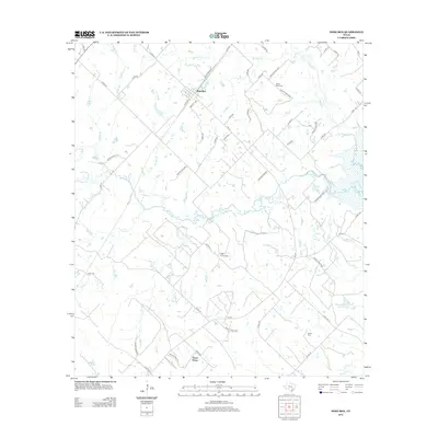
2013 Map of Dime Box
USGS Topo · Published 2013About this map
Dime Box serves as the primary hub for this section of Lee County, its streets including Industry Ave and Guy M Bryan Dr oriented along the local road network. The landscape is defined by the complex drainage of the Yegua Creek system, where the Middle Yegua Cr meanders across the center of the quadrangle to meet the West Yegua Cr and East Yegua Cr. This hydrology supported early settlement patterns, as evidenced by the dispersed cemeteries and small communities like Sweet Home found throughout the area.
Find a feature on this map
59 named features on this map. Tap any name to fly to it.
Don’t see what you’re looking for? This feature index may not catch every label — zoom into the map to look around manually.
Map Details
Editions of this 2013 Dime Box Map
This is the sole edition of this map. No revisions or reprints were ever made.
Other maps of this area

1919 · Giddings
USGS Topo · 1:62,500

1919 · Dime Box
USGS Topo · 1:62,500

1954 · Austin
USGS Topo · 1:250,000

1956 · Somerville
USGS Topo · 1:62,500

1958 · Ledbetter
USGS Topo · 1:24,000

1958 · Carmine
USGS Topo · 1:24,000
1958 · Giddings
USGS Topo · 1:24,000

1959 · Flag Pond
USGS Topo · 1:24,000
1959 · Dime Box
USGS Topo · 1:24,000
1960 · Tanglewood
USGS Topo · 1:24,000