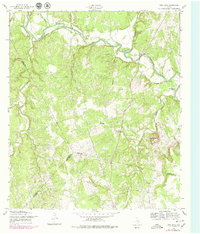
1958 Map of Ding Dong
USGS Topo · Published 1979About this map
The Lampasas River meanders across the northern portion of this Central Texas landscape, anchoring the small settlements of Maxdale and the colorfully named Ding Dong. Based on field work from the late 1950s with late-1970s updates, the survey reveals a rural territory defined by sharp topographic relief and the convergence of three counties. The rugged slopes of Hog Mountain and Wolf Ridge overlook a network of creek branches, including Rocky Creek and Wilson Branch, which carve through the limestone terrain.
Find a feature on this map
21 named features on this map. Tap any name to fly to it.
Don’t see what you’re looking for? This feature index may not catch every label — zoom into the map to look around manually.
Map Details
Editions of this 1958 Ding Dong Map
4 editions found
Other maps of this area

1893 · Georgetown
USGS Topo · 1:125,000

1894 · Gatesville
USGS Topo · 1:125,000

1930 · Killeen
USGS Topo · 1:62,500

1947 · Fort Hood
USGS Topo · 1:62,500

1947 · Killeen
USGS Topo · 1:62,500

1947 · McMillan Mountains
USGS Topo · 1:24,000

1947 · Killeen
USGS Topo · 1:24,000

1947 · Copperas Cove
USGS Topo · 1:24,000

1954 · Waco
USGS Topo · 1:250,000

1954 · Austin
USGS Topo · 1:250,000