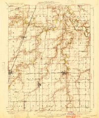
1924 Map of Divernon
USGS Topo · Published 1924About this map
Agricultural lands south of Springfield reveal a densely settled landscape of the 1920s, characterized by a tight network of country schools and coal-era rail lines. The South Fork Sangamon River meanders through the eastern townships of Cotton Hill and South Fork, where legacy landmarks like the Cotton Hill Academy and South Fork Church served established rural communities. The survey captures the transition of transportation in Sangamon County, documenting the path of State Highway No 4 alongside multiple rail corridors, including the Illinois Traction System (Electric). Regional hubs such as Divernon, Chatham, and Auburn are shown at their early twentieth-century peak, surrounded by dozens of family-named school districts including the Mottarville School and Patton School. This detail provides a rare view of the social geography before the consolidation of rural schoolhouses and the reorganization of the central Illinois prairie.
Find a feature on this map
79 named features on this map. Tap any name to fly to it.
Don’t see what you’re looking for? This feature index may not catch every label — zoom into the map to look around manually.
Map Details
Editions of this 1924 Divernon Map
2 editions found
Other maps of this area

1907 · Springfield
USGS Topo · 1:62,500

1909 · Tallula
USGS Topo · 1:62,500

1922 · Divernon
USGS Topo · 1:62,500

1923 · Carlinville
USGS Topo · 1:48,000

1923 · Taylorville
USGS Topo · 1:62,500

1923 · Raymond
USGS Topo · 1:62,500

1924 · Divernon
USGS Topo · 1:62,500

1924 · Waverly
USGS Topo · 1:62,500

1925 · Taylorville
USGS Topo · 1:62,500

1925 · Carlinville
USGS Topo · 1:62,500