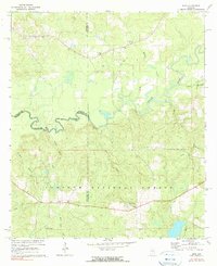
1971 Map of Dixie
USGS Topo · Published 1990About this map
The Conecuh River meanders across the landscape of southern Alabama, defining the boundary between Conecuh, Escambia, and Covington counties as it appeared in the late 1960s and early 1970s. The southern portion of this area is dominated by the Conecuh National Forest, where the small settlement of Dixie and the Dixie Lookout Tower stand near the headwaters of Bear Head Creek. The map reveals a rural community deeply tied to its local landmarks, with numerous family and church-affiliated burial grounds such as Welfare Cem, Feagin Cem, and Mason Cem scattered throughout the piney woods.
Find a feature on this map
30 named features on this map. Tap any name to fly to it.
Don’t see what you’re looking for? This feature index may not catch every label — zoom into the map to look around manually.
Map Details
Editions of this 1971 Dixie Map
3 editions found

Other maps of this area

1953 · Andalusia
USGS Topo · 1:250,000

1957 · Andalusia
USGS Topo · 1:250,000

1971 · Dixie
USGS Topo · 1:24,000

1971 · Bradley
USGS Topo · 1:24,000

1971 · Carolina
USGS Topo · 1:24,000

1971 · Wing
USGS Topo · 1:24,000

1971 · River Falls
USGS Topo · 1:24,000

1971 · Loango
USGS Topo · 1:24,000

1982 · Damascus
USGS Topo · 1:24,000
1982 · Brooklyn
USGS Topo · 1:24,000