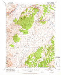
1952 Map of Dixie Flats
USGS Topo · Published 1965About this map
The Hastings Cut-Off and the California Trail converge near the Humboldt River, marking a landscape defined by westward expansion and early transportation routes. In the early 1950s, this region of Elko County shows a transitional economy where historic mining interests at the Site of Old Bullion and Bullion meet active ranching operations like Porter Ranch, Tomera Ranch, and Scott Ranch. The geography is dominated by Grindstone Mountain and Spring Canyon Mountain, while the Southern Pacific and Western Pacific railroads parallel the river, facilitating the transport of goods through the canyon. Notable landmarks such as the Tonka Tunnel and the Airway Beacon near Carlin highlight the technological layers added to these ancient pathways through White Sage Flat.
Find a feature on this map
35 named features on this map. Tap any name to fly to it.
Don’t see what you’re looking for? This feature index may not catch every label — zoom into the map to look around manually.
Map Details
Editions of this 1952 Dixie Flats Map
4 editions found
Other maps of this area

1934 · Jiggs
USGS Topo · 1:125,000

1937 · Jiggs
USGS Topo · 1:125,000

1952 · Dixie Flats
USGS Topo · 1:62,500

1952 · Pine Valley
USGS Topo · 1:62,500

1952 · Carlin
USGS Topo · 1:62,500

1955 · Winnemucca
USGS Topo · 1:250,000

1955 · Elko
USGS Topo · 1:250,000

1956 · Robinson Mtn
USGS Topo · 1:62,500

1957 · Elko West
USGS Topo · 1:24,000

1957 · Elko East
USGS Topo · 1:24,000