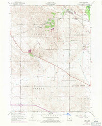
1953 Map of Dixon
USGS Topo · Published 1971About this map
Dixon serves as the primary hub of this eastern Iowa landscape, situated along the C M St P & P railroad line just before it heads east toward New Dixon. The area's mid-century educational landscape is exceptionally well-documented, featuring a network of local institutions like the Dreyer School, Round Grove School, and Fairview Independent School. Settlement patterns follow the natural drainage of Walnut Creek and Mud Creek, while social life is anchored by Hope Church, Memorial Park, and the Conestoga Girl Scout Camp. A significant transportation shift is visible through a dismantled railroad segment cutting through the townships of Liberty and Allens Grove. The presence of these specific school and township labels provides an excellent resource for researchers tracing property locations and community centers during the early 1950s.
Find a feature on this map
22 named features on this map. Tap any name to fly to it.
Don’t see what you’re looking for? This feature index may not catch every label — zoom into the map to look around manually.
Map Details
Editions of this 1953 Dixon Map
3 editions found
Other maps of this area

1890 · Durant
USGS Topo · 1:62,500

1891 · DeWitt
USGS Topo · 1:62,500

1891 · Davenport
USGS Topo · 1:62,500

1892 · Wheatland
USGS Topo · 1:62,500

1894 · Wheatland
USGS Topo · 1:62,500

1894 · Durant
USGS Topo · 1:62,500

1894 · Davenport
USGS Topo · 1:62,500

1901 · Rock Island
USGS Topo · 1:125,000

1910 · Rock Island
USGS Topo · 1:125,000
1953 · Donahue
USGS Topo · 1:24,000