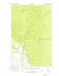
1963 Map of Doe Mountain
USGS Topo · Published 1976About this map
The Chewack River carves a deep valley through the high country of the Okanogan National Forest, serving as the primary corridor for movement and recreation in the early 1960s. This survey reveals a landscape managed for both wildlife and forestry, highlighted by the presence of the Methow Game Range and the Eightmile Guard Station. Transportation is defined by a network of primitive roads and trails that connect isolated campgrounds such as Falls Creek Campground and Nice Camp Campground to prominent peaks like Tripod Peak and Farewell Peak. The placement of a Lookout on First Butte underscores the historical importance of fire observation in this timber-rich region. To the south, more open terrain near Lewis Butte and Sullivan Pond shows the transition toward the valley floor, where the environment shifts from dense forest to the rangelands of the Methow Valley.
Find a feature on this map
80 named features on this map. Tap any name to fly to it.
Don’t see what you’re looking for? This feature index may not catch every label — zoom into the map to look around manually.
Map Details
Editions of this 1963 Doe Mountain Map
2 editions found

Other maps of this area

1899 · Methow
USGS Topo · 1:125,000

1901 · Methow
USGS Topo · 1:125,000

1905 · Okanogan
USGS Topo · 1:125,000

1906 · Chopaka
USGS Topo · 1:125,000

1954 · Okanogan
USGS Topo · 1:250,000

1955 · Concrete
USGS Topo · 1:250,000

1956 · Loup Loup
USGS Topo · 1:62,500

1956 · Tiffany Mountain
USGS Topo · 1:62,500

1956 · Horseshoe Basin
USGS Topo · 1:62,500

1958 · Concrete
USGS Topo · 1:250,000