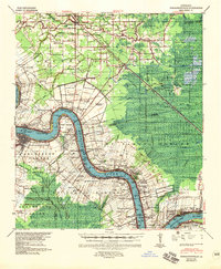
1939 Map of Donaldsonville
USGS Topo · Published 1957About this map
The Mississippi River winds through this 1939 survey, defining the borders of Ascension Parish, St James Parish, and Assumption Parish. Centered on Donaldsonville, the landscape is a dense network of river-oriented commerce and agriculture, where the Illinois Central and Texas and Pacific Ry railroads connect long-standing riverfront tracts. Beyond the levee, the map documents the transition from established settlements like Gonzales and Burnside to the low-lying eastern terrain marked by McElroy Ridge and Junction Ridge.
Find a feature on this map
113 named features on this map. Tap any name to fly to it.
Don’t see what you’re looking for? This feature index may not catch every label — zoom into the map to look around manually.
Map Details
Editions of this 1939 Donaldsonville Map
5 editions found

Other maps of this area

1892 · Lac Des Allemands
USGS Topo · 1:62,500

1892 · Mount Airy
USGS Topo · 1:62,500

1892 · Donaldsonville
USGS Topo · 1:62,500

1892 · Thibodaux
USGS Topo · 1:62,500

1908 · Baton Rouge
USGS Topo · 1:62,500

1927 · Thibodaux NW
USGS Topo · 1:31,680

1932 · Lac Des Allemands NW
USGS Topo · 1:31,680

1932 · Thibodaux NE
USGS Topo · 1:31,680

1934 · Denham Springs
USGS Topo · 1:62,500

1934 · Springfield
USGS Topo · 1:62,500