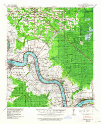
1939 Map of Donaldsonville
USGS Topo · Published 1964About this map
Mississippi River bends define the landscape of this late 1930s survey, where the sugar economy and river-borne industry converge. The map documents an era of transition as the Airline Highway and Illinois Central railroad lines modernized the region alongside traditional riverfront estates like Riverton Plantation and Conway Plantation. For genealogists, the sheet is exceptionally dense with parish history, specifically documenting integrated community centers such as Little Zion Sch Ch & Cem and St Landry Ch & Cem. Inland from the river, the Sorrento Oil Field and Darrow Oil Field signal the rise of the petroleum industry. The complex drainage network of Bayou Francois and the Panama Canal illustrates the extensive engineering required to manage the wetlands between the river and the Amite River basin.
Find a feature on this map
125 named features on this map. Tap any name to fly to it.
Don’t see what you’re looking for? This feature index may not catch every label — zoom into the map to look around manually.
Map Details
Editions of this 1939 Donaldsonville Map
5 editions found

Other maps of this area

1892 · Lac Des Allemands
USGS Topo · 1:62,500

1892 · Mount Airy
USGS Topo · 1:62,500

1892 · Donaldsonville
USGS Topo · 1:62,500

1892 · Thibodaux
USGS Topo · 1:62,500

1908 · Baton Rouge
USGS Topo · 1:62,500

1927 · Thibodaux NW
USGS Topo · 1:31,680

1932 · Lac Des Allemands NW
USGS Topo · 1:31,680

1932 · Thibodaux NE
USGS Topo · 1:31,680

1934 · Denham Springs
USGS Topo · 1:62,500

1934 · Springfield
USGS Topo · 1:62,500