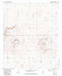
1972 Map of Dora NW
USGS Topo · Published 1985About this map
The high plains of Roosevelt County are defined here by a sparse, industrial landscape of resource extraction and water management. Red Lake serves as a central landmark in this arid terrain, where the topography is meticulously detailed with five-foot contour intervals. This 1970s-era survey highlights the expansion of infrastructure across the Llano Estacado, including a prominent Pipeline cutting through the southern sections and numerous subterranean assets marked as Well and Drill Hole. The presence of several Gravel Pits and a central Water Tank suggests a working landscape focused on ranching and energy exploration. For the local historian or geologist, the map provides a clear record of the physical modifications made to this prairie environment before later developments in the region.
Find a feature on this map
6 named features on this map. Tap any name to fly to it.
Don’t see what you’re looking for? This feature index may not catch every label — zoom into the map to look around manually.
Map Details
Editions of this 1972 Dora NW Map
2 editions found
Other maps of this area

1954 · Clovis
USGS Topo · 1:250,000

1954 · Brownfield
USGS Topo · 1:250,000

1957 · Portales
USGS Topo · 1:62,500

1958 · Brownfield
USGS Topo · 1:250,000

1958 · Clovis
USGS Topo · 1:250,000

1962 · Brownfield
USGS Topo · 1:250,000

1972 · Dora NW
USGS Topo · 1:24,000

1972 · Dora SW
USGS Topo · 1:24,000
1972 · Pep
USGS Topo · 1:24,000

1972 · Dora
USGS Topo · 1:24,000