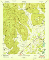
1950 Map of Doran Cove
USGS Topo · Published 1950About this map
Cumberland Plateau terrain dominates this 1950 survey, where the dramatic slopes of Montague Mtn and Summerhouse Mountain drop into the fertile valley of Jeffries Cove. The landscape is a mix of agricultural tradition and industrial modernization, evidenced by the presence of numerous small family cemeteries like Talley Cem and Walker Cem alongside the heavy construction of the Widows Creek Steam Plant near the riverbank.
Find a feature on this map
84 named features on this map. Tap any name to fly to it.
Don’t see what you’re looking for? This feature index may not catch every label — zoom into the map to look around manually.
Map Details
Editions of this 1950 Doran Cove Map
2 editions found
Other maps of this area

1886 · Stevenson
USGS Topo · 1:125,000

1892 · Stevenson
USGS Topo · 1:125,000

1895 · Stevenson
USGS Topo · 1:125,000

1895 · Sewanee
USGS Topo · 1:125,000

1936 · Orme
USGS Topo · 1:24,000

1936 · Bridgeport
USGS Topo · 1:24,000

1936 · Wannville
USGS Topo · 1:24,000

1936 · Flat Rock
USGS Topo · 1:24,000

1936 · Sinking Cove
USGS Topo · 1:24,000

1936 · Stevenson
USGS Topo · 1:24,000