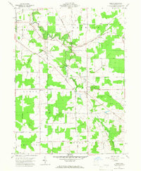
1959 Map of Dorset
USGS Topo · Published 1967About this map
Dorset serves as the central hub of this Ashtabula County landscape, situated at the junction of the New York Central Railroad and several prominent local thoroughfares. The map details a transition from the structured street grid of Jefferson in the northwest to the agricultural expanse of Denmark and Lenox townships. The drainage patterns of Mill Creek and Pymatuning Creek define the low-lying terrain, while the presence of a Gas Well and family-named roads like Traxler Road and Gardner Road suggest the rural industrial and domestic character of the area in the late 1950s. Genealogists will find particular value in the survey's inclusion of small burial grounds, such as South Denmark Cem and Williams Cem, which anchor the history of early families within the Connecticut Western Reserve.
Find a feature on this map
40 named features on this map. Tap any name to fly to it.
Don’t see what you’re looking for? This feature index may not catch every label — zoom into the map to look around manually.
Map Details
Editions of this 1959 Dorset Map
4 editions found
Other maps of this area

1905 · Andover
USGS Topo · 1:48,000

1905 · Ashtabula
USGS Topo · 1:62,500

1905 · Jefferson
USGS Topo · 1:62,500

1906 · Conneaut
USGS Topo · 1:62,500

1907 · Andover
USGS Topo · 1:62,500

1907 · Jefferson
USGS Topo · 1:62,500

1950 · Cleveland
USGS Topo · 1:250,000

1956 · Cleveland
USGS Topo · 1:250,000

1959 · Dorset
USGS Topo · 1:24,000
1959 · Andover
USGS Topo · 1:24,000