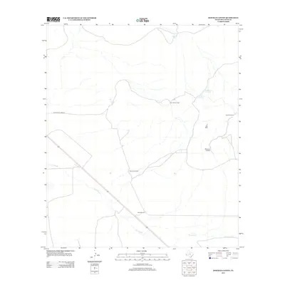
2012 Map of Dowman Canyon
USGS Topo · Published 2012About this map
Agua Caliente Lodge stands as a focal point in this portion of Jeff Davis County, accessed by the appropriately named Agua Calient Lodge Rd. The landscape is defined by its water management infrastructure, essential for ranching and survival in this arid environment. A network of windmills, including the Sauerkraut Windmill, Caliche Windmill, and Dowman Windmill, indicates a history of active land use and livestock grazing. The terrain is dominated by the geological formations of Dowman Canyon and the Y Six Hills, while drainage is carved by the winding path of Tally Slough. Numerous tanks like the Old Chalk Hill Tank and Ocotillo Tank highlight the strategic placement of water catchment across the varied elevations. This record captures the practical necessities of West Texas life, where family-named landmarks and water sources anchor the remote geography.
Find a feature on this map
12 named features on this map. Tap any name to fly to it.
Don’t see what you’re looking for? This feature index may not catch every label — zoom into the map to look around manually.
Map Details
Editions of this 2012 Dowman Canyon Map
This is the sole edition of this map. No revisions or reprints were ever made.
Other maps of this area

1892 · Chispa
USGS Topo · 1:125,000

1894 · Valentine
USGS Topo · 1:125,000

1895 · Chispa
USGS Topo · 1:125,000

1897 · Valentine
USGS Topo · 1:125,000

1897 · Chispa
USGS Topo · 1:125,000

1943 · Valentine
USGS Topo · 1:125,000

1959 · Marfa
USGS Topo · 1:250,000

1965 · Marfa
USGS Topo · 1:250,000

1972 · Chispa
USGS Topo · 1:24,000
1972 · Chispa Mountain
USGS Topo · 1:24,000