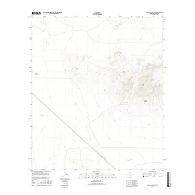
2016 Map of Dowman Canyon
USGS Topo · Published 2016About this map
Dowman Canyon and the surrounding high ground of the Y-Six Hills characterize this high-desert landscape in Jeff Davis County. Water management is a primary feature of the local topography, represented by numerous catchment points such as Old Chalk Hill Tank, New Chalk Hill Tank, and Dagger Tank. These artificial reservoirs are essential to supporting life and livestock in the arid climate, scattered across the slopes and flats between the hills and the Lobo Valley to the west.
Find a feature on this map
9 named features on this map. Tap any name to fly to it.
Don’t see what you’re looking for? This feature index may not catch every label — zoom into the map to look around manually.
Map Details
Editions of this 2016 Dowman Canyon Map
This is the sole edition of this map. No revisions or reprints were ever made.
Other maps of this area

1892 · Chispa
USGS Topo · 1:125,000

1894 · Valentine
USGS Topo · 1:125,000

1895 · Chispa
USGS Topo · 1:125,000

1897 · Valentine
USGS Topo · 1:125,000

1897 · Chispa
USGS Topo · 1:125,000

1943 · Valentine
USGS Topo · 1:125,000

1959 · Marfa
USGS Topo · 1:250,000

1965 · Marfa
USGS Topo · 1:250,000

1972 · Chispa
USGS Topo · 1:24,000
1972 · Chispa Mountain
USGS Topo · 1:24,000