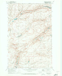
1969 Map of Draper Lake
USGS Topo · Published 1972About this map
The Wheat Ridge Grange Hall stands as a focal point of rural community life in this high-plateau region of Lincoln County. This 1960s landscape is defined by the unique coulees and scablands characteristic of the area, notably the deep carving of Marlin Hollow and the drainage of Canniwai Creek. The map documents a sparse but vital network of water sources, including small pools like Draper Lake and Bergeau Lake, which are often accompanied by Springs and an Eagle Spring to the south. The presence of a Gravel Pit and numerous wells suggests a landscape where local industry and agriculture are dictated by the underlying geology. Transportation is limited to a grid of section-line roads and a specialized Jeep Trail, illustrating the remote nature of the terrain between the northern and southern townships.
Find a feature on this map
17 named features on this map. Tap any name to fly to it.
Don’t see what you’re looking for? This feature index may not catch every label — zoom into the map to look around manually.
Map Details
Editions of this 1969 Draper Lake Map
This is the sole edition of this map. No revisions or reprints were ever made.
Other maps of this area

1953 · Ritzville
USGS Topo · 1:250,000

1959 · Ritzville
USGS Topo · 1:250,000

1965 · Ritzville
USGS Topo · 1:250,000

1968 · Coffeepot Lake
USGS Topo · 1:24,000

1968 · Pacific Lake
USGS Topo · 1:24,000

1968 · Sullivan Lake
USGS Topo · 1:24,000

1969 · Almira SE
USGS Topo · 1:24,000

1969 · Govan
USGS Topo · 1:24,000

1969 · Creston Butte
USGS Topo · 1:24,000

1969 · Wagner Lake
USGS Topo · 1:24,000