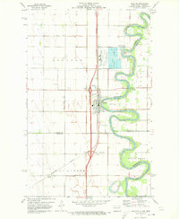
1971 Map of Drayton
USGS Topo · Published 1973About this map
The Red River meanders in tight oxbows along the border of North Dakota and Minnesota, anchoring the landscape of this 1970s survey. The city of Drayton serves as the primary hub, situated where the Burlington Northern railroad corridor meets the river's western bank. A heavy industrial footprint is evident just north of the city center, where large Settling Basins and a Sewage Disposal Pond signify local water management and processing needs of the era.
Find a feature on this map
22 named features on this map. Tap any name to fly to it.
Don’t see what you’re looking for? This feature index may not catch every label — zoom into the map to look around manually.
Map Details
Editions of this 1971 Drayton Map
2 editions found
Other maps of this area

1918 · Acton
USGS Topo · 1:62,500

1939 · Drayton
USGS Topo · 1:62,500

1939 · Glasston
USGS Topo · 1:62,500

1941 · Drayton
USGS Topo · 1:62,500

1941 · Glasston
USGS Topo · 1:62,500

1943 · Grafton
USGS Topo · 1:62,500

1952 · Thief River Falls
USGS Topo · 1:250,000

1956 · Thief River Falls
USGS Topo · 1:250,000

1957 · Thief River Falls
USGS Topo · 1:250,000
1960 · Big Woods NW
USGS Topo · 1:24,000