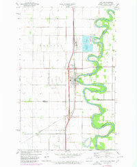
1971 Map of Drayton
USGS Topo · Published 1980About this map
The meandering Red River defines this borderland landscape between North Dakota and Minnesota, where the community of Drayton serves as a primary crossing and hub. In the early 1970s, the area reflects a transition in infrastructure, with the Burlington Northern railroad and the modern Herrick Interchange facilitating regional movement. To the south, the rail stop at Herrick and the small settlement of Robbin on the eastern bank represent the sparse but vital agricultural network of the Red River Valley.
Find a feature on this map
21 named features on this map. Tap any name to fly to it.
Don’t see what you’re looking for? This feature index may not catch every label — zoom into the map to look around manually.
Map Details
Editions of this 1971 Drayton Map
2 editions found
Other maps of this area

1918 · Acton
USGS Topo · 1:62,500

1939 · Drayton
USGS Topo · 1:62,500

1939 · Glasston
USGS Topo · 1:62,500

1941 · Drayton
USGS Topo · 1:62,500

1941 · Glasston
USGS Topo · 1:62,500

1943 · Grafton
USGS Topo · 1:62,500

1952 · Thief River Falls
USGS Topo · 1:250,000

1956 · Thief River Falls
USGS Topo · 1:250,000

1957 · Thief River Falls
USGS Topo · 1:250,000
1960 · Big Woods NW
USGS Topo · 1:24,000