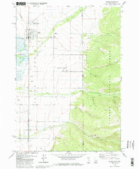
1978 Map of Driggs
USGS Topo · Published 1986About this map
Teton Basin is the central landscape of this 1970s survey, showing the agricultural and logistical layout of eastern Idaho before modern development. The town of Driggs serves as the local hub, anchored by the Union Pacific railroad and the Driggs-Teton Peaks Municipal Airport. The map documents the vital water infrastructure of the era, including the Cherry Grove Canal and Kimball Canal, which supported the surrounding valley farms. To the east, the terrain rises sharply into the Targhee National Forest, where steep drainage features like Darby Canyon and Rock Creek contrast with the flat valley floor. For genealogists and local historians, the sheet preserves the location of the Driggs Cem and Driggs-Darby Cem, along with outlying settlements such as Darby and Chapin, providing a clear record of rural Teton County at this time.
Find a feature on this map
37 named features on this map. Tap any name to fly to it.
Don’t see what you’re looking for? This feature index may not catch every label — zoom into the map to look around manually.
Map Details
Editions of this 1978 Driggs Map
2 editions found
Other maps of this area

1899 · Grand Teton
USGS Topo · 1:125,000

1901 · Grand Teton
USGS Topo · 1:125,000

1943 · Driggs
USGS Topo · 1:62,500

1946 · Driggs
USGS Topo · 1:62,500

1955 · Driggs
USGS Topo · 1:250,000

1958 · Driggs
USGS Topo · 1:250,000

1962 · Driggs
USGS Topo · 1:250,000

1965 · Clawson
USGS Topo · 1:24,000
1965 · Tetonia
USGS Topo · 1:24,000
1968 · Granite Basin
USGS Topo · 1:24,000