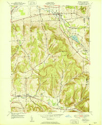
1951 Map of Dryden
USGS Topo · Published 1951About this map
Dryden and the surrounding township appear at a mid-century peak of rural development, characterized by a complex network of upland roads and fertile valleys. The Lehigh Valley Railroad corridor provides a central industrial artery, passing through Willow Glen and skimming the edge of Dryden Lake. To the south, the village of Slaterville Springs anchors the Sixmile Creek valley, where the historic Catskill Turnpike follows the water's path toward West Slaterville. The terrain is defined by prominent elevations such as Yellow Barn Hill and Beam Hill, which dictate the winding paths of rural routes like Irish Settlement Road. For genealogists, the map identifies several distinct burial grounds, including the Dutch Reformed Cem and Mulks Cem, providing valuable location data for family history research in this part of Tompkins County.
Find a feature on this map
41 named features on this map. Tap any name to fly to it.
Don’t see what you’re looking for? This feature index may not catch every label — zoom into the map to look around manually.
Map Details
Editions of this 1951 Dryden Map
2 editions found
Other maps of this area

1898 · Moravia
USGS Topo · 1:62,500

1900 · Dryden
USGS Topo · 1:62,500

1902 · Moravia
USGS Topo · 1:62,500

1903 · Cortland
USGS Topo · 1:62,500

1903 · Harford
USGS Topo · 1:62,500

1906 · Catatonk
USGS Topo · 1:125,000

1942 · Groton
USGS Topo · 1:24,000

1943 · West Groton
USGS Topo · 1:31,680

1943 · Groton
USGS Topo · 1:31,680

1944 · Cortland
USGS Topo · 1:31,680