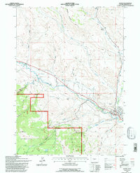
1991 Map of Dubois
USGS Topo · Published 1997About this map
Dubois sits at the confluence of several watercourses in this high-altitude landscape, where the Wind River winds through the valley floor. The map highlights the town's transition from early ranching at sites like the Shipley Ranch to modern infrastructure including the Dubois Airport. Notable geological and natural curiosities are documented, such as a Natural Bridge and an inactive geyser in the Warm Spring Canyon area. Much of the surrounding territory is managed by the Shoshone National Forest, with boundaries clearly marked against private ranch lands. The presence of an abandoned landing field and a telephone line corridor suggest shifts in transportation and communication across the basin. Water management is evident through various gulches and small reservoirs like Hart Reservoir and Grandy Reservoir, which supported local agricultural and ranching efforts.
Find a feature on this map
36 named features on this map. Tap any name to fly to it.
Don’t see what you’re looking for? This feature index may not catch every label — zoom into the map to look around manually.
Map Details
Editions of this 1991 Dubois Map
This is the sole edition of this map. No revisions or reprints were ever made.
Other maps of this area

1905 · Younts Peak
USGS Topo · 1:125,000

1907 · Younts Peak
USGS Topo · 1:125,000

1909 · Fremont Peak
USGS Topo · 1:125,000

1955 · Thermopolis
USGS Topo · 1:250,000

1956 · Indian Point
USGS Topo · 1:24,000

1956 · Dubois
USGS Topo · 1:24,000

1956 · Esmond Park
USGS Topo · 1:24,000

1956 · Ramshorn Peak
USGS Topo · 1:24,000

1956 · Warm Spring Mountain
USGS Topo · 1:24,000

1956 · Mason Draw
USGS Topo · 1:24,000