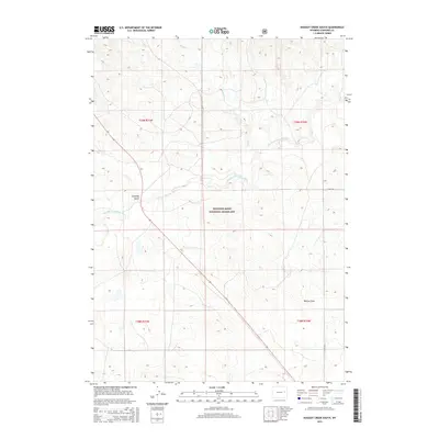
2015 Map of Dugout Creek South
USGS Topo · Published 2015About this map
The Thunder Basin National Grassland dominates this portion of the high plains in Converse County, where the ephemeral waters of the Dry Fork Cheyenne River carve a meandering path through the arid landscape. The topography is defined by significant drainage systems, including the namesake Dugout Cr and the descriptively named Calamity Gulch. As of 2015, the area remains primarily open range, with the section-line grid of the Public Land Survey System overlaying a terrain marked by deep draws like Willow Draw. Transportation is sparse, anchored by the diagonal route of Highway 59 and local gravel arteries such as Steinle Rd, illustrating the characteristic isolation of Wyoming's eastern grasslands and its legacy as a preserved national landscape.
Find a feature on this map
11 named features on this map. Tap any name to fly to it.
Don’t see what you’re looking for? This feature index may not catch every label — zoom into the map to look around manually.
Map Details
Editions of this 2015 Dugout Creek South Map
This is the sole edition of this map. No revisions or reprints were ever made.
Other maps of this area

1955 · Newcastle
USGS Topo · 1:250,000

1958 · Newcastle
USGS Topo · 1:250,000

1959 · Bill
USGS Topo · 1:62,500

1959 · Betty Reservoir
USGS Topo · 1:62,500

1970 · Bill 4 NW
USGS Topo · 1:24,000

1971 · Coal Bank Draw
USGS Topo · 1:24,000

1971 · Tin Can Lake
USGS Topo · 1:24,000

1979 · Bill
USGS Topo · 1:100,000
1984 · Dugout Creek North
USGS Topo · 1:24,000
1984 · Patsy Draw
USGS Topo · 1:24,000