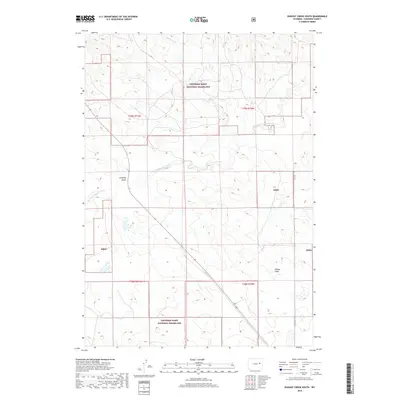
2018 Map of Dugout Creek South
USGS Topo · Published 2018About this map
Thunder Basin National Grassland dominates this expanse of Converse County, where the high plains landscape is defined by the ephemeral flow of the Dry Fork Cheyenne River. This 2018 survey illustrates the vast grazing lands managed by the forest service, characterized by a complex network of seasonal drainages and topographic depressions. Significant watercourses such as Dugout Creek carve through the terrain, while landmarks like Calamity Gulch and Willow Draw provide orientation in an area primarily accessible via unpaved routes like Co Rd 40. The map's detail focuses on the resource management boundaries of the Tbng, showing the township and range divisions that still govern land use and property rights across these public grasslands.
Find a feature on this map
11 named features on this map. Tap any name to fly to it.
Don’t see what you’re looking for? This feature index may not catch every label — zoom into the map to look around manually.
Map Details
Editions of this 2018 Dugout Creek South Map
This is the sole edition of this map. No revisions or reprints were ever made.
Other maps of this area

1955 · Newcastle
USGS Topo · 1:250,000

1958 · Newcastle
USGS Topo · 1:250,000

1959 · Bill
USGS Topo · 1:62,500

1959 · Betty Reservoir
USGS Topo · 1:62,500

1970 · Bill 4 NW
USGS Topo · 1:24,000

1971 · Coal Bank Draw
USGS Topo · 1:24,000

1971 · Tin Can Lake
USGS Topo · 1:24,000

1979 · Bill
USGS Topo · 1:100,000
1984 · Dugout Creek North
USGS Topo · 1:24,000
1984 · Patsy Draw
USGS Topo · 1:24,000