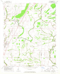
1967 Map of Duncan
USGS Topo · Published 1968About this map
The Hushpuckena River and its meandering tributaries dominate this mid-century Delta landscape, where the agriculture of the day follows the intricate drainage patterns of the Big Sunflower River basin. The town of Duncan and the smaller settlement of Alligator are centers of community life, both anchored by the Illinois Central railroad. An Indian Mound serves as a tangible link to much earlier inhabitants, positioned near the wetlands of Annis Brake. The distribution of local institutions is dense, with numerous country churches such as Niland Chapel, Union Grove Ch, and Mt Evergreen Ch scattered across the township lines. Irrigation and water management are evident through features like the Siphon and several Flume labels, reflecting the intensive land use required for Delta farming. A small Landing Strip and the Illinois Central tracks highlight the logistical importance of transportation in this rural Bolivar and Coahoma County borderland.
Find a feature on this map
46 named features on this map. Tap any name to fly to it.
Don’t see what you’re looking for? This feature index may not catch every label — zoom into the map to look around manually.
Map Details
Editions of this 1967 Duncan Map
2 editions found
Other maps of this area

1930 · Mellwood
USGS Topo · 1:62,500

1931 · Drew
USGS Topo · 1:48,000

1935 · Clarksdale
USGS Topo · 1:62,500

1935 · Mound Bayou
USGS Topo · 1:62,500

1939 · Pace
USGS Topo · 1:62,500

1939 · Clarksdale
USGS Topo · 1:62,500

1939 · Mellwood
USGS Topo · 1:62,500

1948 · Helena
USGS Topo · 1:250,000

1950 · Helena
USGS Topo · 1:250,000

1953 · Greenwood
USGS Topo · 1:250,000