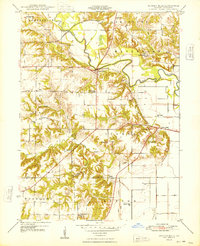
1948 Map of Duncan Mills
USGS Topo · Published 1948About this map
The Spoon River snakes through the heart of this post-war landscape, carving a wide valley through the townships of Isabel, Waterford, and Pleasant. The settlement of Duncan Mills serves as a local hub near the river crossing, where the Chicago Burlington and Quincy railroad line skirts the northern bluffs. This 1947 survey captures a dense network of rural infrastructure, notably an unusually high concentration of country schools such as Wild Goose Sch, Oak Ridge Sch, and Hickory Sch, reflecting the community structure of Fulton County before the mid-century trend of district consolidation.
Find a feature on this map
35 named features on this map. Tap any name to fly to it.
Don’t see what you’re looking for? This feature index may not catch every label — zoom into the map to look around manually.
Map Details
Editions of this 1948 Duncan Mills Map
3 editions found

Other maps of this area

1918 · Vermont
USGS Topo · 1:62,500

1921 · Vermont
USGS Topo · 1:62,500

1925 · Havana
USGS Topo · 1:62,500

1926 · Beardstown
USGS Topo · 1:62,500

1930 · Chandlerville
USGS Topo · 1:62,500

1932 · Chandlerville
USGS Topo · 1:62,500

1944 · Beardstown
USGS Topo · 1:62,500

1947 · Lewistown
USGS Topo · 1:24,000

1947 · St. David
USGS Topo · 1:24,000

1947 · Havana
USGS Topo · 1:24,000