
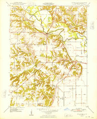
1948 Map of Duncan Mills
USGS Topo · Published 1948About this map
The Spoon River meanders through this portion of Fulton County, shaping the rural landscape near Duncan Mills. This 1948 survey reveals a territory defined by small school districts and family cemeteries, reflecting a mid-century agrarian social structure. Educational hubs such as the Duncan Mills School, Otto Sch, and Kerton Valley Sch are scattered across the townships of Isabel, Waterford, and Woodland.
Find a feature on this map
34 named features on this map. Tap any name to fly to it.
Don’t see what you’re looking for? This feature index may not catch every label — zoom into the map to look around manually.
Map Details
Editions of this 1948 Duncan Mills Map
3 editions found
Other maps of this area

1918 · Vermont
USGS Topo · 1:62,500

1921 · Vermont
USGS Topo · 1:62,500

1925 · Havana
USGS Topo · 1:62,500

1926 · Beardstown
USGS Topo · 1:62,500

1930 · Chandlerville
USGS Topo · 1:62,500

1932 · Chandlerville
USGS Topo · 1:62,500

1944 · Beardstown
USGS Topo · 1:62,500

1947 · Lewistown
USGS Topo · 1:24,000

1947 · St. David
USGS Topo · 1:24,000

1947 · Havana
USGS Topo · 1:24,000