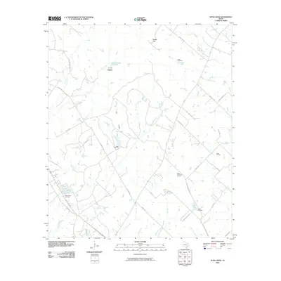
2010 Map of Dunn Creek
USGS Topo · Published 2010About this map
Dunns Fort serves as a central landmark in this Robertson County landscape, where the terrain is defined by a dense network of creeks and small impoundments. The geography is shaped by waterways like Dunn Creek, Spring Creek, and Persimmon Creek, many of which feed into private and named reservoirs such as P and M Bank Club Lake and Pryor Lake. This pattern of water management is a defining characteristic of the area, with numerous small dams like the Seale Lake Dam and Savoy-Gant Lake Dam dotting the drainages.
Find a feature on this map
46 named features on this map. Tap any name to fly to it.
Don’t see what you’re looking for? This feature index may not catch every label — zoom into the map to look around manually.
Map Details
Editions of this 2010 Dunn Creek Map
This is the sole edition of this map. No revisions or reprints were ever made.
Other maps of this area

1954 · Austin
USGS Topo · 1:250,000

1956 · Bryan
USGS Topo · 1:62,500

1956 · Caldwell
USGS Topo · 1:62,500

1961 · Mumford
USGS Topo · 1:24,000

1961 · Hearne North
USGS Topo · 1:24,000

1961 · Hearne South
USGS Topo · 1:24,000

1962 · Edge
USGS Topo · 1:24,000

1962 · Wheelock
USGS Topo · 1:24,000

1962 · Bryan East
USGS Topo · 1:24,000
1962 · Bryan West
USGS Topo · 1:24,000