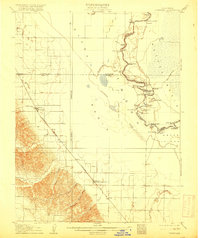
1907 Map of Dunnigan
USGS Topo · Published 1916About this map
The Sacramento River meanders through a complex network of bends and sloughs in this early 20th-century depiction of the California interior. The map illustrates a landscape defined by the Colusa Basin and Sutter Basin, where the river's path is marked by family-named landings such as Mummas Landing, Boyer's Landing, and Poffenbergers Landing. These points served as vital river-trade connections before the dominance of rail. Inland, the Southern Pacific (Woodland Line) anchors several settlements, most notably Dunnigan and Zamora Blacks Station PO. The topography reveals the transition from the flat basin lands to the foothills of Oat Valley, with numerous seasonal watercourses like Buckeye Creek and Bird Creek draining toward the central lowlands. Genealogists will find interest in the specific placement of forgotten stops like Wycoff and Britona along the iron road.
Find a feature on this map
52 named features on this map. Tap any name to fly to it.
Don’t see what you’re looking for? This feature index may not catch every label — zoom into the map to look around manually.
Map Details
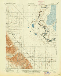
Editions of this 1907 Dunnigan Map
3 editions found
Other maps of this area

1888 · Marysville
USGS Topo · 1:125,000

1891 · Marysville
USGS Topo · 1:125,000

1894 · Marysville
USGS Topo · 1:125,000

1895 · Marysville
USGS Topo · 1:125,000

1905 · Harrington
USGS Topo · 1:24,000

1905 · Esparto
USGS Topo · 1:24,000

1907 · Dunnigan
USGS Topo · 1:62,500

1907 · Colusa
USGS Topo · 1:62,500

1907 · Woodland
USGS Topo · 1:62,500

1907 · Davisville
USGS Topo · 1:62,500