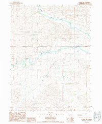
1986 Map of Dunning SW
USGS Topo · Published 1987About this map
The Nebraska National Forest dominates the northern reaches of this mid-1980s landscape, representing a significant man-made forest initiative within the Sandhills. The terrain is defined by the braided paths of the Middle Loup River and the Dismal River, which cut through the undulating dune topography characteristic of this part of Blaine County. A secondary drainage, Wild Horse Creek, flows through the south-central portion of the quadrangle. Aside from a small Gravel Pit, the area remains largely undeveloped, showcasing the vast agricultural and conservation tracts of the central Nebraska plains. This survey, produced from photography taken in 1985, captures the hydrological network and range management boundaries at the height of the decade's land-use patterns.
Find a feature on this map
8 named features on this map. Tap any name to fly to it.
Don’t see what you’re looking for? This feature index may not catch every label — zoom into the map to look around manually.
Map Details
Editions of this 1986 Dunning SW Map
This is the sole edition of this map. No revisions or reprints were ever made.
Other maps of this area

1948 · Linscott
USGS Topo · 1:62,500

1948 · Halsey
USGS Topo · 1:62,500

1950 · Linscott
USGS Topo · 1:62,500

1950 · Halsey
USGS Topo · 1:62,500

1951 · Dunning
USGS Topo · 1:62,500

1951 · Hoagland
USGS Topo · 1:62,500

1954 · North Platte
USGS Topo · 1:250,000

1956 · North Platte
USGS Topo · 1:250,000

1957 · North Platte
USGS Topo · 1:250,000

1967 · North Platte
USGS Topo · 1:250,000