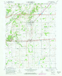
1970 Map of Dunreith
USGS Topo · Published 1991About this map
National Road and the Conrail line intersect at Dunreith, a key junction in this central Indiana landscape. To the north, the town of Spiceland is surrounded by agricultural plots and industrial markers like Stone Quarry Mills and various Gravel Pits. The topography is defined by the winding course of the Blue River and several smaller tributaries including Buck Creek and Duck Creek. Family-named cemeteries such as Mason Cem and Hickside Cem are scattered across the townships, providing significant data points for genealogical research. The map also documents mid-century cultural features like a Drive-in Theater near the Norfolk and Western tracks and a Gas Well in the southern portion of the quadrangle. Regional transport is highlighted by historic routes like Old Spiceland Road and the Old National Road, which predate the more modern highway infrastructure shown passing through the area.
Find a feature on this map
34 named features on this map. Tap any name to fly to it.
Don’t see what you’re looking for? This feature index may not catch every label — zoom into the map to look around manually.
Map Details
Editions of this 1970 Dunreith Map
3 editions found
Other maps of this area

1948 · Lewisville
USGS Topo · 1:24,000

1949 · New Castle West
USGS Topo · 1:24,000

1950 · New Castle East
USGS Topo · 1:24,000

1950 · Dunreith
USGS Topo · 1:24,000

1950 · Lewisville
USGS Topo · 1:24,000

1953 · Cincinnati
USGS Topo · 1:250,000

1957 · Cincinnati
USGS Topo · 1:250,000

1959 · Mays
USGS Topo · 1:24,000

1959 · Falmouth
USGS Topo · 1:24,000

1960 · New Castle West
USGS Topo · 1:24,000