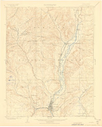
1908 Map of Durango
USGS Topo · Published 1908About this map
Durango serves as the industrial and transport hub for the Animas Valley during this early twentieth-century period, anchored by the Durango Smelter and the busy yards of the Denver and Rio Grande R. R. The map illustrates a landscape transitioning from wild terrain to a resource-driven economy, where narrow-gauge rail lines like the Denver and Silverton Line hug the banks of the Animas River. High-altitude mining operations are prominent in the surrounding peaks, including the Neglected Mine and Boston Coal Mine, supported by processing sites like the Oro Fino Mill.
Find a feature on this map
68 named features on this map. Tap any name to fly to it.
Don’t see what you’re looking for? This feature index may not catch every label — zoom into the map to look around manually.
Map Details
Editions of this 1908 Durango Map
3 editions found

Other maps of this area

1895 · La Plata
USGS Topo · 1:62,500

1897 · La Plata
USGS Topo · 1:62,500

1897 · Rico
USGS Topo · 1:62,500

1898 · Durango
USGS Topo · 1:62,500

1898 · Engineer Mountain
USGS Topo · 1:62,500

1898 · Rico
USGS Topo · 1:62,500

1899 · La Plata
USGS Topo · 1:62,500

1899 · Rico
USGS Topo · 1:62,500

1900 · Engineer Mountain
USGS Topo · 1:62,500

1900 · Needle Mountains
USGS Topo · 1:62,500