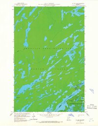
1959 Map of Dutton Lake
USGS Topo · Published 1966About this map
The international boundary between Canada and the United States defines the character of this 1950s survey, marking a complex water-bound landscape at the intersection of Quetico Provincial Park and the Superior National Forest. This remote wilderness on Hunter Island is characterized by an intricate chain of glacial lakes, including the uniquely named sequence of Other Man Lake, This Man Lake, and No Man Lake.
Find a feature on this map
29 named features on this map. Tap any name to fly to it.
Don’t see what you’re looking for? This feature index may not catch every label — zoom into the map to look around manually.
Map Details
Editions of this 1959 Dutton Lake Map
3 editions found
Other maps of this area

1957 · Ensign Lake
USGS Topo · 1:62,500

1957 · Quetico
USGS Topo · 1:250,000

1959 · Ogishkemuncie Lake
USGS Topo · 1:24,000

1959 · Kekekabic Lake
USGS Topo · 1:24,000

1959 · Dutton Lake
USGS Topo · 1:24,000

1959 · Ester Lake
USGS Topo · 1:24,000

1968 · Quetico
USGS Topo · 1:250,000
1976 · Ensign Lake SE
USGS Topo · 1:24,000

1977 · Basswood Lake
USGS Topo · 1:100,000
1981 · Ensign Lake East
USGS Topo · 1:24,000