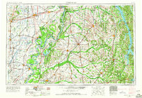
1956 Map of Dyersburg
USGS Topo · Published 1966About this map
The Mississippi River and Ohio River converge in this mid-century survey, revealing a landscape defined by complex hydrology and major transportation corridors. The intricate network of the Obion River and its forks dominates the southern reaches, while the alluvial plains of Missouri are carved by the Little River and Saint Johns Bayou. A significant regional feature is Reelfoot Lake, formed by seismic events and protected by the Reelfoot National Wildlife Refuge. The map captures the rail-heavy economy of the era, showing the intersection of the Illinois Central, Louisville and Nashville, and Gulf Mobile and Ohio railroads. From the elevated Sikeston Ridge to the massive impoundment of Kentucky Lake on the eastern edge, this document records the post-war industrial and agricultural layout of the Four Rivers region.
Find a feature on this map
96 named features on this map. Tap any name to fly to it.
Don’t see what you’re looking for? This feature index may not catch every label — zoom into the map to look around manually.
Map Details
Editions of this 1956 Dyersburg Map
4 editions found

Other maps of this area

1908 · Princeton
USGS Topo · 1:62,500

1910 · Princeton
USGS Topo · 1:62,500

1925 · Reelfoot Lake
USGS Topo · 1:62,500

1926 · Paducah
USGS Topo · 1:62,500

1928 · Eddyville
USGS Topo · 1:48,000

1928 · La Center
USGS Topo · 1:62,500

1929 · Smithland
USGS Topo · 1:62,500

1929 · Paducah
USGS Topo · 1:62,500

1931 · Sikeston
USGS Topo · 1:62,500

1931 · Eddyville
USGS Topo · 1:62,500