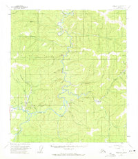
1956 Map of Eagle A-2
USGS Topo · Published 1972About this map
The settlement of Chicken serves as the focal point for this interior Alaska survey, where the legacy of early gold mining is etched into the landscape. Reminders of the region's extraction history are visible through Placer Mine operations and extensive Dredge Tailings along the creeks. The Taylor Highway provides the primary overland route through this remote territory, connecting small outposts and aviation infrastructure like the Franklin Landing Strip and Lassen Landing Strip.
Find a feature on this map
38 named features on this map. Tap any name to fly to it.
Don’t see what you’re looking for? This feature index may not catch every label — zoom into the map to look around manually.
Map Details
Editions of this 1956 Eagle A-2 Map
2 editions found
Other maps of this area

1899 · Fortymile
USGS Topo · 1:250,000

1949 · Tanacross
USGS Topo · 1:250,000

1950 · Tanacross
USGS Topo · 1:250,000

1951 · Eagle
USGS Topo · 1:250,000

1956 · Tanacross D-3
USGS Topo · 1:63,360

1956 · Tanacross D-2
USGS Topo · 1:63,360

1956 · Tanacross D-1
USGS Topo · 1:63,360

1956 · Eagle A-1
USGS Topo · 1:63,360

1956 · Eagle B-2
USGS Topo · 1:63,360

1956 · Eagle A-2
USGS Topo · 1:63,360