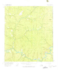
1956 Map of Eagle B-1
USGS Topo · Published 1975About this map
The Fortymile River carves a deep path through this eastern Alaska landscape along the international boundary, anchoring a region defined by its mid-century mining and aviation infrastructure. Gold-seeking history is evident at Bonanza Bar and various Placer Mines dotted throughout the drainage basins of McKinley Creek and Columbia Creek. Transportation in this era relied on the Taylor Highway and several backcountry routes, including a Tractor Trail and a winter landing strip. Remote outposts like the Dome Creek Shelter Cabin and isolated Cabins near Little Miller Creek provided essential refuge for those navigating the terrain between Fortymile Dome and the United States Canada border. The map also highlights specific aviation points such as the Eldon Landing Strip, which served as critical access for the remote mineral claims of the Fortymile district.
Find a feature on this map
40 named features on this map. Tap any name to fly to it.
Don’t see what you’re looking for? This feature index may not catch every label — zoom into the map to look around manually.
Map Details
Editions of this 1956 Eagle B-1 Map
3 editions found
Other maps of this area

1899 · Fortymile
USGS Topo · 1:250,000

1951 · Eagle
USGS Topo · 1:250,000

1956 · Eagle C-1
USGS Topo · 1:63,360

1956 · Eagle C-2
USGS Topo · 1:63,360

1956 · Eagle A-1
USGS Topo · 1:63,360

1956 · Eagle B-2
USGS Topo · 1:63,360

1956 · Eagle A-2
USGS Topo · 1:63,360

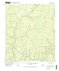
1956 · Eagle B-1
USGS Topo · 1:63,360

1957 · Eagle
USGS Topo · 1:250,000
2018 · Eagle A-1 NW
USGS Topo · 1:25,000