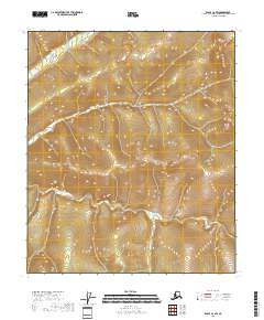
2018 Map of Eagle C-2 SW
USGS Topo · Published 2018About this map
Champion Cr flows across the southern reaches of this interior Alaskan landscape, which was documented by the Geological Survey in the early 21st century. The terrain is defined by a dense network of watercourses and elevation contours, representing the high country within the Southeast Fairbanks Census Area. To the north, Bear Cr and Comet Cr drain through the high ridges, illustrating the natural watershed patterns of the region. This 2018 survey serves as a record of the wilderness and hydrography within the public land system, specifically across Township 3 South through Township 5 South. The lack of road infrastructure or named settlements on the map underscores the remote nature of this portion of the Yukon-Tanana Uplands, where geographic study remains focused on the primary drainage systems and topographical relief.
Find a feature on this map
9 named features on this map. Tap any name to fly to it.
Don’t see what you’re looking for? This feature index may not catch every label — zoom into the map to look around manually.
Map Details
Editions of this 2018 Eagle C-2 SW Map
This is the sole edition of this map. No revisions or reprints were ever made.
Other maps of this area

1899 · Fortymile
USGS Topo · 1:250,000

1951 · Eagle
USGS Topo · 1:250,000

1956 · Eagle C-2
USGS Topo · 1:63,360

1956 · Eagle B-2
USGS Topo · 1:63,360

1956 · Eagle B-3
USGS Topo · 1:63,360

1956 · Eagle C-3
USGS Topo · 1:63,360

1957 · Eagle
USGS Topo · 1:250,000
2018 · Eagle C-3 SE
USGS Topo · 1:25,000
2018 · Eagle C-3 NE
USGS Topo · 1:25,000
2018 · Eagle B-2 NW
USGS Topo · 1:25,000