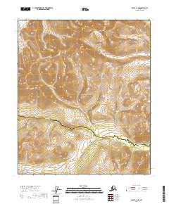
2018 Map of Eagle C-6 NW
USGS Topo · Published 2018About this map
Yukon-Charley Rivers National Preserve dominates this section of the interior, illustrating a remote landscape defined by the serpentine path of the Charley River. Flowing through the southern portion of the quadrangle, the river marks the lower elevations of an otherwise high-altitude terrain, where contour lines tightly gather around unnamed peaks and ridges. The map captures the meeting point of the Yukon-Koyukuk Census Area Southeast Fairbanks Census Area, showing how modern administrative lines are superimposed over this undeveloped wilderness. This 2018 survey provides a clear view of the complex topography and drainage patterns within the preserve, highlighting the lack of human infrastructure in this protected subarctic environment.
Find a feature on this map
7 named features on this map. Tap any name to fly to it.
Don’t see what you’re looking for? This feature index may not catch every label — zoom into the map to look around manually.
Map Details
Editions of this 2018 Eagle C-6 NW Map
This is the sole edition of this map. No revisions or reprints were ever made.
Other maps of this area

1950 · Big Delta
USGS Topo · 1:250,000

1951 · Big Delta
USGS Topo · 1:250,000

1951 · Eagle
USGS Topo · 1:250,000

1956 · Eagle C-6
USGS Topo · 1:63,360
1956 · Eagle D-6
USGS Topo · 1:63,360

1957 · Eagle
USGS Topo · 1:250,000

1958 · Big Delta D-1
USGS Topo · 1:63,360

1958 · Big Delta C-1
USGS Topo · 1:63,360

1958 · Big Delta
USGS Topo · 1:250,000
2018 · Big Delta C-1 SE
USGS Topo · 1:25,000