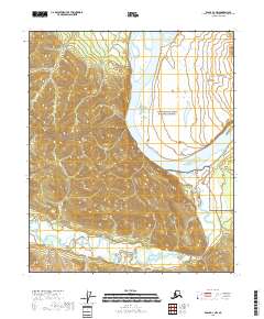
2018 Map of Eagle D-1 NW
USGS Topo · Published 2018About this map
The Yukon River carves a massive arc through the northern landscape of this region, serving as the dominant geographic feature of the Yukon-Charley Rivers National Preserve. This 2018 survey reveals a terrain defined by the complex convergence of significant waterways. To the south, the Seventymile River winds through a dense network of drainages including Sinnott Cr and Thorn Cr, while the Tatonduk River enters from the northeast. The lack of roads or established settlements on this sheet emphasizes the wilderness character of the Southeast Fairbanks Census Area, where the map focus remains entirely on the natural hydrography and the preservation boundaries. Researchers can trace the intricate braided channels and seasonal floodplains that have shaped travel and trapping routes for generations along the Big Boulder Cr and Thurston Cr.
Find a feature on this map
12 named features on this map. Tap any name to fly to it.
Don’t see what you’re looking for? This feature index may not catch every label — zoom into the map to look around manually.
Map Details
Editions of this 2018 Eagle D-1 NW Map
This is the sole edition of this map. No revisions or reprints were ever made.
Other maps of this area

1899 · Fortymile
USGS Topo · 1:250,000

1951 · Charley River
USGS Topo · 1:250,000

1951 · Eagle
USGS Topo · 1:250,000

1956 · Charley River A-2
USGS Topo · 1:63,360

1956 · Charley River A-1
USGS Topo · 1:63,360

1956 · Charley River
USGS Topo · 1:250,000

1956 · Eagle D-2
USGS Topo · 1:63,360
1956 · Eagle D-1
USGS Topo · 1:63,360

1957 · Eagle
USGS Topo · 1:250,000
2018 · Charley River A-2 SE
USGS Topo · 1:25,000