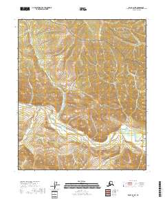
2018 Map of Eagle D-2 NE
USGS Topo · Published 2018About this map
The Seventymile River serpentines through the southern half of this landscape, its path defined by a series of dramatic bends within the Yukon-Charley Rivers National Preserve. This portion of the Southeast Fairbanks Census Area is characterized by a dense network of drainages feeding into the main river, including Crooked Cr, Mogul Cr, and Broken Neck Cr. The terrain is marked by steep elevation changes, particularly around Lucky Gulch and Flume Gulch, which suggest the challenging topography encountered by early prospectors or travelers in this region.
Find a feature on this map
20 named features on this map. Tap any name to fly to it.
Don’t see what you’re looking for? This feature index may not catch every label — zoom into the map to look around manually.
Map Details
Editions of this 2018 Eagle D-2 NE Map
This is the sole edition of this map. No revisions or reprints were ever made.
Other maps of this area

1899 · Fortymile
USGS Topo · 1:250,000

1951 · Charley River
USGS Topo · 1:250,000

1951 · Eagle
USGS Topo · 1:250,000

1956 · Charley River A-2
USGS Topo · 1:63,360

1956 · Charley River A-1
USGS Topo · 1:63,360

1956 · Charley River
USGS Topo · 1:250,000

1956 · Eagle D-2
USGS Topo · 1:63,360
1956 · Eagle D-1
USGS Topo · 1:63,360

1957 · Eagle
USGS Topo · 1:250,000
2018 · Charley River A-2 SE
USGS Topo · 1:25,000