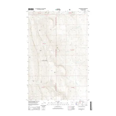
2014 Map of Ear Mountain
USGS Topo · Published 2014About this map
Ear Mtn stands as a prominent landmark within the high terrain of the Lewis & Clark National Forest, where steep drainages and isolated peaks define the Teton County landscape. This 2014 survey documents a complex network of canyons and gulches, including Riordon Gulch, Bear Gulch, and Slim Gulch, which channel water toward major tributaries. The northern boundary is marked by the S Fork Teton River, while the central and southern reaches are drained by various forks of Willow Creek and Deep Creek, such as N Fork Willow Cr and N Fork Deep Cr. Human infrastructure is sparse, limited to peripheral access points like S Fork Rd and Meltwater Rd. The map provides a detailed view of the natural barriers and drainage patterns, including features like Wind Mtn and Chute Mtn, which have likely influenced land use and accessibility in this part of Montana for generations.
Find a feature on this map
35 named features on this map. Tap any name to fly to it.
Don’t see what you’re looking for? This feature index may not catch every label — zoom into the map to look around manually.
Map Details
Editions of this 2014 Ear Mountain Map
This is the sole edition of this map. No revisions or reprints were ever made.
Other maps of this area

1903 · Saypo
USGS Topo · 1:125,000

1955 · Choteau
USGS Topo · 1:250,000

1957 · Choteau
USGS Topo · 1:250,000

1958 · Choteau
USGS Topo · 1:250,000

1958 · Ear Mountain
USGS Topo · 1:24,000

1958 · Lake Theboe
USGS Topo · 1:24,000

1958 · Cave Mountain
USGS Topo · 1:24,000

1958 · Mount Wright
USGS Topo · 1:24,000
1958 · Twin Lakes
USGS Topo · 1:24,000

1958 · Our Lake
USGS Topo · 1:24,000