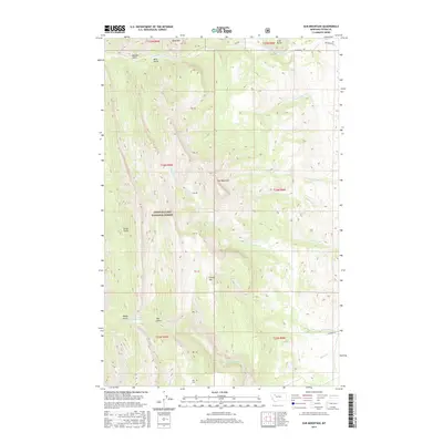
2017 Map of Ear Mountain
USGS Topo · Published 2017About this map
Ear Mountain dominates this portion of the Lewis & Clark National Forest, rising above a complex network of drainages that define the eastern edge of the Front Range. The landscape is carved by steep erosional features such as Rierdon Gulch, Bear Gulch, and Green Gulch, which all feed into the larger hydrological systems of the S Fork Teton River and S Fork Willow Cr.
Find a feature on this map
36 named features on this map. Tap any name to fly to it.
Don’t see what you’re looking for? This feature index may not catch every label — zoom into the map to look around manually.
Map Details
Editions of this 2017 Ear Mountain Map
This is the sole edition of this map. No revisions or reprints were ever made.
Other maps of this area

1903 · Saypo
USGS Topo · 1:125,000

1955 · Choteau
USGS Topo · 1:250,000

1957 · Choteau
USGS Topo · 1:250,000

1958 · Choteau
USGS Topo · 1:250,000

1958 · Ear Mountain
USGS Topo · 1:24,000

1958 · Lake Theboe
USGS Topo · 1:24,000

1958 · Cave Mountain
USGS Topo · 1:24,000

1958 · Mount Wright
USGS Topo · 1:24,000
1958 · Twin Lakes
USGS Topo · 1:24,000

1958 · Our Lake
USGS Topo · 1:24,000